
Can this thunderstorm season in N. Ireland get any better?. It seems that I'm getting storms here on a regular basis and it's getting to the point where I just expect them now. What a difference this has been in comparison to the 2008 season when I was hoping, praying, and hopecasting for storms that only showed on a handful of days with great gaps between the action. I seen two more storms pass over my own home town on previous days with stunning late evening convection which produced plenty of rumbles over the Co. Derry area along with a brief funnel cloud and several low level wall clouds. I haven't even posted those images anywhere yet but might get around to it at some stage. July 15th 2009 was another action packed day and the forecast looked very encouraging indeed with an unstable moist Wly airflow thanks to a low pressure system over the Atlantic which was a set-up more typical of what we would expect to get in the Autumn here. Instability was good with CAPE values in excess of 1100 and an LI of -3 combined with some wind shear and various convergence zones and troughs across the country in a weakly capped environment. This set-up would almost guarantee organized multicell thunderstorms breaking out anywhere with a risk of vortex development.
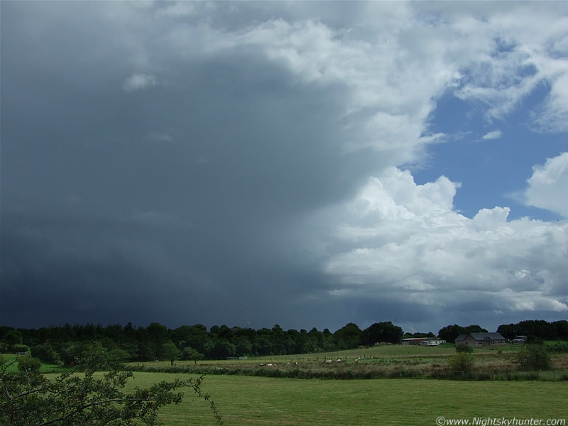
As always, I can tell at a glance by looking at the sky early in the day if the chances are good for storms. You can just tell by looking at the convection during the middle of the day when the Sun really begins to heat the ground and fuel those towering cumulus clouds up. Anyone who knew anything about storms would have noted the high potential in an instant. With such strong solar heating I watched in amazement as line after line of huge towers formed in long trains crossing the sky from W to E on very obvious convergence lines. Convergence lines/zones are areas where winds from directions and different speeds meet/merge (converge) in a particular area which is usually a place which stretches for miles. It is here, on that zone/line, that convection is most vigorous and the likelihood of storms/funnels/tornadoes are much higher. A 360 degree scan of the sky around Maghera showed this very process in action. The convection had all the visual hallmarks of storm potential, the huge vertical height, the organized lines, the well defined low level bases, the crisp/sharp cauliflower tops with rapid movement as the towers exploded up with energy. It was a like a timer on a bomb waiting to detonate. A check on the animated sat images showed convection erupting over all of N. Ireland and the radar had the strong multiple echoes of heavy showers breaking out and intensifying.
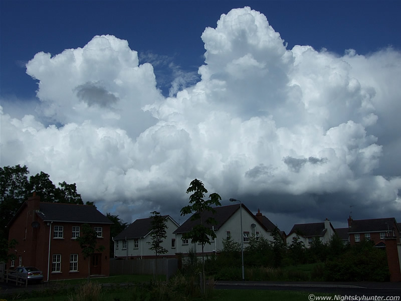 |
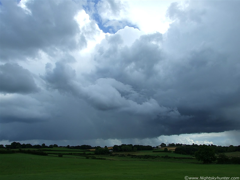
Here's an example of the high quality convection on this day. This was actually taken from my front door step looking N at one section of a convergence line. It's the classic appearance of a convective weather day with fabulous crisp updraughts expanding by the sec. The entire sky was filled with scenes like this and those lines never seemed to stop as they arrived over the Sperrins from the W. At this stage I went out to the country immediately, storms were likely to develop at any moment, and besides, those towers are big producers of funnel clouds in this country so I wanted to get out as a quickly as possible to a good spot so I could monitor the bases of those young updraughts like a Hawk. So that's what I did.
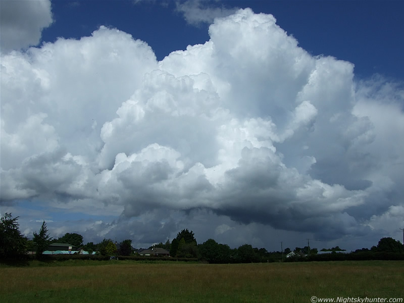 |
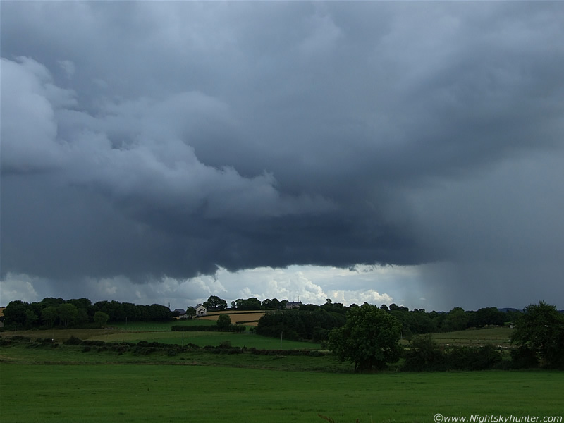
Looking N again with more convection passing over the Coleraine Road (behind trees) from L to R. I relocated to the countryside on the NE section of Maghera to one of my favourite places. I barely took my eyes from the sky the entire time as there was so much going on with so much potential. Some of those towers began to glaciate (turn to ice) within min's showing that it was time for the formation of big Cumulonimbus (cb) cells. I got to my location in good time but I was already badly dehydrating due to the intense sunshine and heat, I was sweating like crazy and felt dry and dizzy. I should have brought a bottle of water with me.
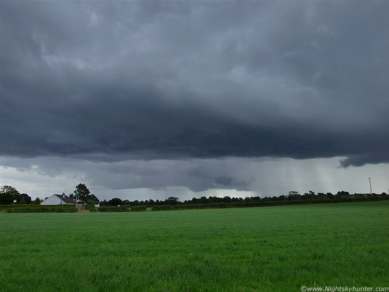
I was impressed by how quickly things were happening so early in the afternoon. There was a line of updraught towers which caught my eye. They where behind me in the W and slowly moving passed me, when to my S they seemed to explode with energy and began to merge into one large mountain of cloud consisting of multiple towers. The group began to back-build and soon a solid black rain free base at formed. The towers continued shooting up at the rear with the lead and central towers turing to ice as they grew their own anvil canopies. This was a multicell growing before my very eyes within min's. The base of this line was very low to the ground and soon a lowering with a nice textured base formed at the front which was an obvious shelf cloud/gust front which I could see side-on from my vantage point. Strings of precip began to break out as a shower formed, it was already turning into a storm.
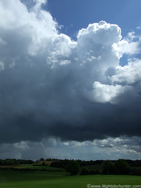 |
In reality, everything in these images was much larger than it seems on here. This is one of those towers at the rear of the line reaching up higher and higher. An anvil is forming to the L, up and out of frame, and another was well developed to the R out of frame.
 |
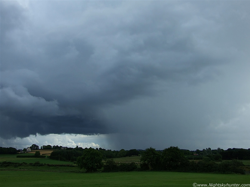
Several cbs were now born with rear sweeping anvils shining brilliant white, almost blinding, in the intense sunshine. Some mid level cloud began to fill the gaps in between the cells like a crazy convective plasterer and the belly of the young storm darkened. The inflow was very impressive with scud and accessory clouds getting sucked up into the inflow area with rapid speed. Two areas along the base could clearly be seen rotating counter clockwise so it was at this point in the day that I knew there would be funnel clouds somewhere. I hoped at the time that I would be one of those lucky people to see one today.
 |
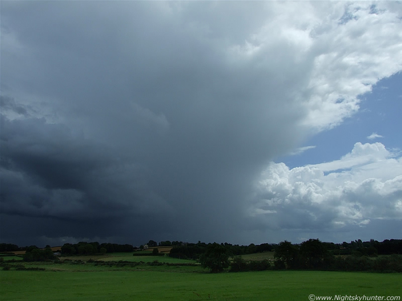
Two large wispy anvils overhead began to dim the sunlight and cast cooler shadows across the land which I was very grateful for. I at last was able to cool down a little, and at the same taking images with the camera was easier because I could actually see through the viewfinder/LCD screen without the glare of the Sun. You can see a small section of those anvils at the top of the frame burnt out due to the Sun reflecting off the ice crystals. The falling precip/shower began to take on a life of its own and intensified. It was at this point in time that the thunderstorm was born. Looking SE here with the storm moving R to L. I just caught a bright blue in-cloud (i-c) flash of lightning in the corner of my eye within that precip followed by an angry rumble of thunder. Now the game had begun!.
 |
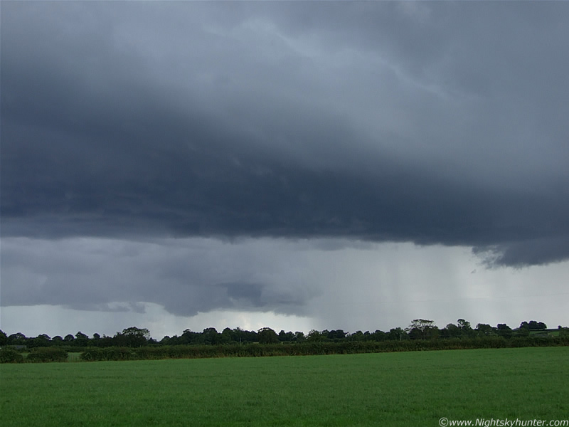
A second, and more intense precip core broke out quickly below the other cb at the rear of the line to the R. More rumbles of thunder. Everything was so slow moving that it felt like it was going on forever.
 |
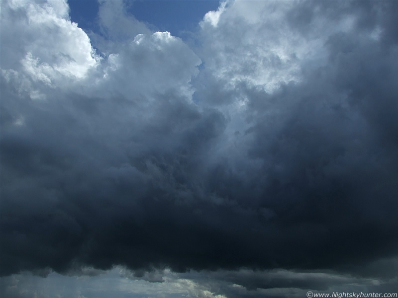
The second precip core intensified further and looked extremely well defined on its LHS which looked really cool. Now there were regular rumbles of angry thunder, a little distant however clearly audible and rumbling for a long period of time and with great regularity. There was alot of electrical activity from this storm but unfortunately almost all of the lightning was hidden within and on the other side of the L precip core so I could only hear the thunder. Amazingly the big precip core on the R had no lightning so far. The scud to the L was dancing upwards rapidly with rotation in places.
 |
A good while later the moving storm eventually revealed its rear to me and a nice flanking line of new towers could be seen going up fast. The R precip core now began producing periodic lightning and rumbling thunder.
 |
You can see here that the anvil on that rear cb looked quite chunky for a time. The storm continued into the distance with the odd rumble breaking the otherwise silent day except for the call of a Buzzard circling high in the sky and the singing of Birds in the trees. I watched that flanking line for a while for funnels but there was no joy so I went back home again. It was nice to get a storm so early in the day, often a good sign of more to come later. The high CAPE would remain until 18.00 in the early evening so there was plenty of time left to see more. Even though this storm hid the majority of its lightning I was still pleased with it and quite liked the structure on it.
Here's a sort video clip of that storm showing it at different stages. There's some thunder on it however most of it wasn't picked up by the speaker and the gentle breeze messed with the audio a little too. Not really an exciting video but it shows the structure pretty good.
During the late afternoon back at home I logged onto the net and checked out the Ukweatherworld forum to see what had been happening while I was away. I seen several exciting reports of large multicell storms stretching for miles from NW Lough Neagh across to Belfast where spectacular lightning was taking place. The radar and sferics confirmed powerful storms in those areas so the temptation was more than strong to get out there. I walked outside my house and looked to the S and SW and seen huge storm cells miles away, however the anvils were so large that I could see them far above Slieve Gallion mountain with mammatus even from here!. It looked very dark on the horizon and very promising. My Aunt was visiting at the time so from the back garden I pointed out the anvils and towering cu and told her the areas below those were getting hammered by heavy rain and lightning. She was shocked that we could see those storms from so far away. They where not moving N, rather E, so they where not going to approach Maghera so that left one other option...chase them. So after much debating about where to go we decided to pursue those storms. The NW shore of Lough Neagh was the target area, hopefully we could get there before the storms died out. So we hit the road and head SE into the greater region of instability.
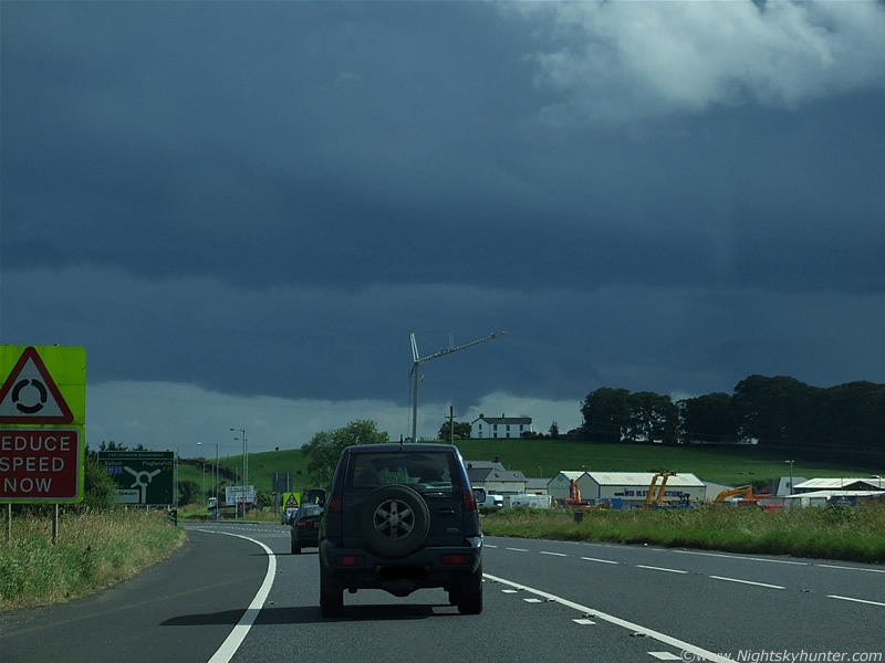 |
This was shot through the car windscreen. Approaching the roundabout outside Magherafelt. I was amazed to see those big storms even at this time. The base of those multicells stretched for miles across the sky and already we could see interesting lowerings doing something. I suspect there may already have been more than one funnel before we made it this far.
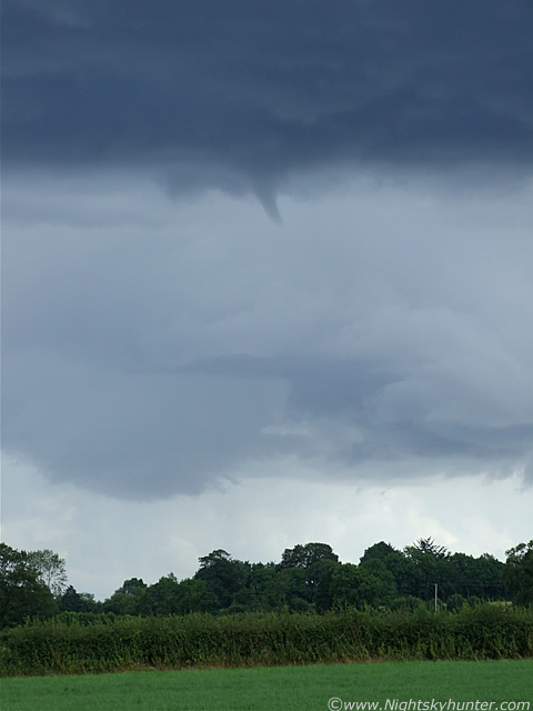
We continued on outside Magherafelt and towards Ballyronan and it was then that we seen a stunning, huge, highly sculptured, and solid updraught base below those storms. It was the kind of updraught base that every chaser likes to see. I knew in an instant this was going to drop a funnel, it had the text book look to it. As we drove through narrow country roads fighting for views of the base through the gaps in trees I seen a narrow funnel cloud form under that base. It was small and very thin like an inverted cone but it was clearly the real deal, I couldn't get any shots of it due to the trees but there was no question about what it was. After several min's it retracted into the base and was gone, however I suspected another was possible at any moment.
 |
At last we found a clearance as we approached a junction. We took the road to our R which brought us parallel with the storm and stopped on a country road near a large field, then got out and watched. This is a portion of that base which boasted alot of motion. Heavy precip was falling behind it where a storm was in progress. These where the same cells I saw from home with the anvils over the mountains so you can appreciate how large they were now that we where so close. They were so large that I just couldn't see them because they had blended into the cloud covering much of the sky.
 |
Within a min of our arrival a funnel cloud appeared again at the same place as the previous one. I couldn't believe my luck.
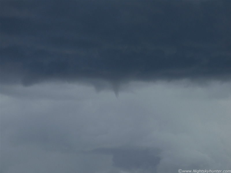 |
It rapidly developed into the classic funnel cloud shape, at first it looked semi-transparent but then it tightened up and became a more solid affair.
 |
This is near Ballyronan Marina on the NW section of Lough Neagh. The funnel was directly above the water here but you can't see it in the image because of that tree line.
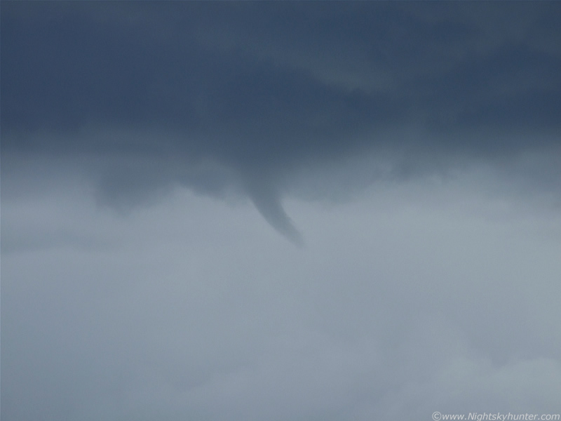 |
Bending nicely, this was fantastic. More on page two.
Martin McKenna